Travel, Atlases, Maps & Natural History
Travel, Atlases, Maps & Natural History

Jean Frédéric Bernard | Relations de la Louisiane...& Recueil d'arrests..., 1720, 2 volumes, 12mo, calf
Lot Closed
November 15, 03:29 PM GMT
Estimate
1,500 - 2,000 GBP
Lot Details
Description
Jean Frédéric Bernard
Two volumes from the 'Recueil de voiages au nord', comprising:
Relations de la Louisiane, et du flueve Mississipi. Amsterdam: Chez Jean Frédéric Bernard, 1720
Recueil d'arrests et autres pièces pour l'établissement de la Compagnie d'Occident, Relation de Detroit et de la baie de Hudson. Amsterdam: Chez Jean Frédéric Bernard, 1720
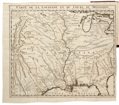
FIRST EDITIONS, 2 volumes, 12mo (169 x 94mm.), Relations de la Lousiane with 2 folding maps and 13 engraved plates, Recueil d'arrests with 3 engraved plates, eighteenth-century speckled calf, spines gilt, titled 'Relati de la Louisia' 'Tom. 1' and 'Tom. 2', red speckled edges, tear to large folding map of Louisiana and Missisippi, minor wear to edges of folding maps, a few marks to covers
Bernard published his Recueil de voiages au Nord in 1720, and here are two of the most important volumes from the series, being volumes 5 and 6. They describe the lands around Louisiana, Mississippi and Virginia as well as Detroit and Hudson's Bay, augmented with maps and engravings depicting North American curiosities including weaponry, snow shoes and beavers. The two large folding maps in Relations de la Louisiane depict the area of Louisiana and the Mississippi from the Gulf of Mexico to Lake Michigan as well as the route across the Atlantic from Europe to the east coast of America.
PROVENANCE:
Cornwell House, inkstamp
