Monochrome | Important Chinese Art
Monochrome | Important Chinese Art

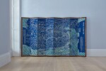
Huang Qianren, A rare and complete Map of the Great Qing’s Ten-Thousand year Unified (Realm of) All under Heaven, Qing dynasty, Daoguang period | 清道光 黃千人 《大清萬年一統地理全圖》木板套印 後裝裱為日本屏風
Auction Closed
November 2, 04:07 PM GMT
Estimate
120,000 - 150,000 GBP
Lot Details
Description
Huang Qianren
A rare and complete Map of the Great Qing’s Ten-Thousand year Unified (Realm of) All under Heaven
Qing Dynasty, Daoguang period
清道光 黃千人 《大清萬年一統地理全圖》木板套印 後裝裱為日本屏風
large woodblock map printed in 16 sections on 8 sheets, mounted on a later folding screen
132 by 235 cm, 52 by 92½ in.
Japanese Private Collection.
日本私人舊藏
Richard A. Pegg, Cartographic Traditions in East AsianMaps, Honolulu, 2014, p. 18-27.
Yan Ping, China in Ancient and Modern Maps, London, 1998, p. 141.
Richard A. Pegg,《Cartographic Traditions in East Asian Maps》,
檀香山,2014年,第18至27頁
Yan Ping,《China in Ancient and Modern Maps》,倫敦,1998年,第141頁
Displaying the grand nature of mountains and rivers, this map pays great attention to the diversity of the Qing lands. It identifies provinces, prefectures, districts, and other administrative divisions by enclosing their names in squares and other shapes whose meanings are interpreted in the introductory inscription. Proudly presenting the newly conquered frontier regions of Tibet and Mongolia, the map glorifies the expansion of the empire in its title wannian yitong (everlasting unification). The inscription ends with the phrase tianxia zhi guang keyi quan lan yan (天下之廣可以全覽焉, ‘the vastness of the world can be seen in full’), indicating the worldview of the Qing court at the peak of its rule. In her article Contending Cartographic Claims? The Qing Empire in Manchu, Chinese, and European Maps, historian Laura Hostetler suggests that with the impressive physical dimension of this map, it served an ‘imperial purpose – to awe those who viewed it with the grandeur of the Qing’.
To underline the proud achievement of the Qing dynasty, the Jiaqing (r. 1796-1820) and Daoguang (r. 1821-50) Emperors, successors of Qianlong, continued to update and reprint Huang Qianren’s map. Some extant copies were later mounted onto folding screens, such as a closely related one in the collection of the Yokohama City University Library and Information Center, Yokohoma, included in the recent exhibition Mapping the World: Perspectives from Asian Cartography, National Library, Singapore, 2021-2; and another eight-fold map screen, of more yellowish colouration, sold at Christie’s London, 12th December 2018, lot 191.