Travel, Photographs, Maps and Natural History
Travel, Photographs, Maps and Natural History

Du Halde | Description de l'empire de Chine, Paris, 1735, 4 volumes, contemporary calf
Lot Closed
November 17, 02:11 PM GMT
Estimate
5,000 - 7,000 GBP
Lot Details
Description
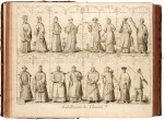
Jean-Baptiste du Halde
Description geographique, historique, chronologique, politique, et physique de l'Empire de la Chine et de la Tartarie Chinoise. Paris: P.G. le Mercier, 1735
4 volumes, folio (429 x 271mm.), half-titles, title-pages printed in red and black with engraved vignette, engraved and woodcut initials and headpieces, vol.1: 25 engraved maps and plates (17 double-page or folding); vol.2: 10 engraved plates (8 folding); vol.3: 5 engraved plates (2 double-page); vol.4: 25 double-page maps, contemporary mottled calf, spines gilt in compartments, occasional browning, bindings very scraped and torn but sound
FIRST EDITION of Du Halde's comprehensive account of the geography, history and culture of the Chinese Empire. Du Halde, a Paris Jesuit, was responsible for the publication of the letters from the missionaries in China, and he used those as the basis for this monumental work, along with maps commissioned from the royal geographer D'Anville. It was dedicated to Louis XV, the patron of the French Jesuit mission to China.
Its success as an account of (mostly) first-hand reports of contemporary China resulted in the pirated edition printed in The Hague in 1736, followed by numerous translations in the following years.
PROVENANCE:
Figli dell'Immacolata Concezione, provincia Lombardia, ink stamp on half-title