Travel, Atlases, Maps & Natural History
Travel, Atlases, Maps & Natural History

HOLLAR | Map of London, 1666
Lot Closed
November 17, 01:33 PM GMT
Estimate
3,000 - 5,000 GBP
Lot Details
Description
HOLLAR, WENCESLAUS
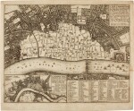
A map or ground plot of the Citty of London… by which is exactly demonstrated the resent condition of thereof since the last sad accident of fire. London: John Overton at the White Horse, 1666
308 x 368mm., engraved map of London, with inset map lower left and inset key to churches lower right, a few minor repairs
HOLLAR’S RARE MAP SHOWING THE AFTERMATH OF THE GREAT FIRE OF LONDON. The central portion of the map, north of the Thames and ranging from Fetter Lane in the west and Tower Hill in the east, is largely blank “signifeing the burnt part” as it says in the title cartouche.
LITERATURE:
Hind B11; Howgego, second edition 19(1); Pennington 1004
