Travel, Atlases, Maps & Natural History
Travel, Atlases, Maps & Natural History

Property of a Distinguished Collector
Lot Closed
November 17, 01:34 PM GMT
Estimate
1,000 - 1,500 GBP
Lot Details
Description
Property of a Distinguished Collector
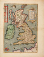
BRITISH ISLES
A collection of six maps and views, 16th and 17th century, comprising:
Blaeu, Joan. Bercheria vernacule Barkshire. Amsterdam, c.1645
Bowen, Emmanuel. Berkshire. London, 1760, 2 sheets joined
Braun, Georg and Franz Hogenberg. Cantabrigia. Cologne, 1572, somewhat browned
Braun, Georg and Franz Hogenberg. Oxonium. Cologne, 1572, somewhat browned
Ortelius, Abraham. Angliae, Scotiae, et Hiberniae. Antwerp, c.1570
Speed, John. The Kingdome of England. London, 16766 double-page engraved maps, coloured by hand, most maps mounted
6 double-page engraved maps, coloured by hand, most maps mounted