Travel, Atlases, Maps and Natural History
Travel, Atlases, Maps and Natural History

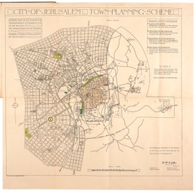
McLean. City of Jerusalem town planning scheme. Alexandria, 1918, presentation copy
Auction Closed
July 28, 03:29 PM GMT
Estimate
1,500 - 2,500 GBP
Lot Details
Description
MCLEAN, WILLIAM H.
City of Jerusalem town planning scheme. (Alexandria: Printed by the Survery of Egypt, 1918)
PRESENTATION COPY (see provenance), large folding map (660 x 670mm., map; 340 x 215mm., binding), backed on linen, mounted within original boards with title printed to upper cover, albumen print of the original manuscript map mounted to front paste-down endpaper, boards rubbed with some discolouration
THE FIRST URBAN MASTER-PLAN FOR JERUSALEM. It "was submitted in June 1918. It was drawn up by the architect William McLean, the Alexandria city-engineer, at the request of General Allenby, the commander-in-chief of the British Army in Palestine. An additional master-plan was prepared by Prof. Patrick Geddes in 1919. Neither of these plans had defined planning boundaries, and incorporated a large part of the land surrounding the built-up area. In 1921, when the urban planning was delimited, it was done with strict reference to these plans" (Kark and Oren-Nordheim).
Manuscript note to front paste-down endpaper regarding the original map, that this map is made from: "Photograph of original plan endorsed as approved by General Sir Edmund Allenby G.C.B. G.C.M.G. and by the Municipality of Jerusalem. This plan was exhibited at the Royal Academy, London, 1919."
LITERATURE:
Kark, Ruth and Michal Oren-Nordheim. Jerusalem and its environs: quarters, neighborhoods, villages, 1800-1948. Jerusalem: Magnes Press, 2001, p. 144
PROVENANCE:
Presentation inscription from the author to Colonel William Edward Donohue C.B.E., Chief Inspector of Mechanical Transport
