Fine Books and Manuscripts, Including Americana
Fine Books and Manuscripts, Including Americana

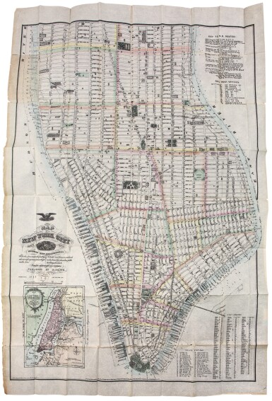
Dripps, Matthew. A fully-colored pocket map, with Thomas Kitchin's map of "New York Island"
Lot Closed
October 15, 04:52 PM GMT
Estimate
2,000 - 3,000 USD
Lot Details
Description
DRIPPS, MATTHEW
MAP OF NEW YORK CITY SOUTH OF 46TH. ST. NEW YORK: M. DRIPPS, 1876
Folding lithographic map (39 3/4 x 26 3/4 in.; 1,010 x 679 mm). Hand-colored in outline; small clean tears to folds, small section at foot of title excised by the publisher, replaced with identical paper and with some manuscript work added. Unbound, as issued, within original dark brown cloth boards blocked in blind, "Dripps' Large Map of N.Y. City" blocked in gilt on upper cover, 1p. letterpress "Catalogue of M. Dripps' Maps" tipped onto front pastedown.
A fully-colored pocket map, with an inset of a copy of Thomas Kitchin's map of "New York Island," which offers lists Police Stations and sub-Post Offices, a street directory, and a key to rail road routes
The title notes that the map also includes details "showing new arrangement Docks, piers and water frontage also soundings and former high-water line Elevated and horse car railroad routes, traced by characters, public buildings, churches, &c. Street directory and numbers." The detail on the map is impressive, with numerous businesses, hotels, banks, theatres, etc. identified, as well as the route of the elevated railway along Greenwich Street—the first elevated railroad in Manhattan. In the same year, Dripps also issued a two-sheet map which extended the area covered north to 135th street but was otherwise similar (the same inset Kitchin map for instance).
REFERENCE:
"Checklist of Maps and Atlases relating to the city of New York in the New York Public Library" in the Bulletin of the New York Public Library (1901), V:71 ("Map...south of 135th Street'); not in Rumsey
