Robert Morden, Philip Lea
Map of London, Westminster & Southwark
Morden, Lea & Christopher Brown
1700
Price:
6,000 USD
International shipping available
Customs duties and taxes may apply.
Ships from: London, United Kingdom
Taxes not included
VAT and other taxes are not reflected in the listed pricing. Read more
Authenticity guaranteed
We guarantee the authenticity of this item.
Details

Description
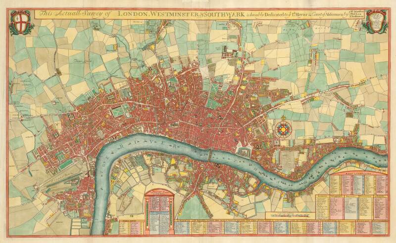
A striking map of London at the start of the 18th century.
- Robert Morden (English).
- Philip Lea (English).
- This Actuall Survey of London, Westminster & Southwark Is humbly dedicated to ye L.d Mayor & Court of Aldermen.
- London: Morden, Lea & Christopher Brown, 1700.
- Colored.
- Two sheets conjoined.
This is the second state of this scarce map, first published in 1690, extending from Hyde Park clockwise to Islington, Hackney, Stepney, Limehouse, Southwark and Lambeth, with many of the important buildings and monuments shown as elevations. Wren's St Paul's Cathedral is shown a decade before the building was completed, so it is shown according to the original plans, which were altered during construction. At the west end of St. James's Park is Arlington House, which now forms the southern wing of Buckingham Palace. On the east side of the Park is the Palace of Whitehall, which was burned down in 1698.
Under the map are extensive numbered tables corresponding with numbers on the map and detailing public offices, wards, halls and companies, markets, inns of court and chancery, prisons, palaces, public buildings, hospitals and parishes.
Literature
Howgego: 42, listed as state ii of v, but states iii-v from a new Dutch plate.
Condition Report
 Very Good
A few small repairs.
Dimensions
Language
Subject
SKU
CPRFY
Conditions of Business
Please note that the cancellation right for EU/UK purchasers applies to this item. Please read Condition 19 of the Buy Now Marketplace Conditions of Business for buyers for more information. Read more here.